Categories
- Antiques & Collectibles 13
- Architecture 36
- Art 48
- Bibles 22
- Biography & Autobiography 813
- Body, Mind & Spirit 141
- Business & Economics 28
- Children's Books 12
- Children's Fiction 9
- Computers 4
- Cooking 94
- Crafts & Hobbies 4
- Drama 346
- Education 46
- Family & Relationships 57
- Fiction 11826
- Games 19
- Gardening 17
- Health & Fitness 34
- History 1377
- House & Home 1
- Humor 147
- Juvenile Fiction 1873
- Juvenile Nonfiction 202
- Language Arts & Disciplines 88
- Law 16
- Literary Collections 686
- Literary Criticism 179
- Mathematics 13
- Medical 41
- Music 40
- Nature 179
- Non-Classifiable 1768
- Performing Arts 7
- Periodicals 1453
- Philosophy 64
- Photography 2
- Poetry 896
- Political Science 203
- Psychology 42
- Reference 154
- Religion 513
- Science 126
- Self-Help 83
- Social Science 81
- Sports & Recreation 34
- Study Aids 3
- Technology & Engineering 59
- Transportation 23
- Travel 463
- True Crime 29
Little Journey to Puerto Rico For Intermediate and Upper Grades
Categories:
Download options:
-

178.25 KB -

380.73 KB
Description:
Excerpt
A LITTLE JOURNEY TO PUERTO RICO
Do you know what people mean when they speak of "Our New Possessions"? What are they? Where are they? Why are men, in the streets, in the shops, everywhere, talking about them? Why are the newspapers full of articles in regard to them? Why are our lawmakers at the capital devoting so much time and attention to them? Can you tell?
Some of these things you can easily ascertain for yourselves. Others we will speak of here.
The new territory which has lately come into the possession of the
United States, consists of the islands of Puerto Rico, Hawaii and the
Philippines. Cuba is not included in this list; it is soon to be an
independent country.
Since Puerto Rico and these other islands have come to be parts of the
United States, everyone is anxious to learn something more of them.
The best way to learn the geography of a country and the customs of the people is to visit the country and see with your own eyes.
That would be a difficult thing for most of us. The next best way is to make the journey in imagination, and that all of us can do.
The island nearest us is Puerto Rico, the most eastern island of the Greater Antilles. Let us visit that first and the other islands later on.
We must find out something of the climate, however, before we start on this journey. This may not be the right season of the year to go. We must know, too, what kind of clothing to take with us.
In order to plan our route wisely, we must know something of the geography of the island. We should also know the past history of Puerto Rico, in order to understand the customs of the people and the conditions that exist there.
* * * * *
LOCATION, SIZE, SURFACE.
If you will find a map of the West Indies in your atlas or geography, you will also find Puerto Rico. It is one of the four Greater Antilles Islands, and lies east of Haiti and farthest out in the Atlantic Ocean.
It is over four hundred miles from the east coast of Cuba, one thousand miles from Havana, and about one thousand four hundred and fifty miles from New York.
In size it is the smallest of the group. Its area is about three thousand five hundred and fifty square miles. Its average length is about ninety-five miles; its average breadth about thirty-five miles.
In shape it resembles the State of Connecticut, though it is only three-fourths the size of that State.
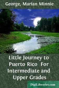
[Illustration: THE ISLAND OF PUERTO RICO.]
Puerto Rico, in English, means Rich Harbor. But Puerto Rico is not rich in harbors. There are not more than six good harbors, but it has less than three hundred and fifty miles of coast line.
The surface of Puerto Rico is mountainous. A range of hills traverses the island from east to west. The hills are low and their sides are covered with vegetation. The hills are not rocky and barren, but are cultivated to their very tops.
[Illustration: AN AFTERNOON SIESTA.]
The lower valleys are rich pasture lands or cultivated plantations. The knolls have orchards of cocoanuts and other trees. Coffee, protected by the shade of other trees, grows to the summits of the green hills....