Categories
- Antiques & Collectibles 13
- Architecture 36
- Art 48
- Bibles 22
- Biography & Autobiography 813
- Body, Mind & Spirit 141
- Business & Economics 28
- Children's Books 12
- Children's Fiction 9
- Computers 4
- Cooking 94
- Crafts & Hobbies 4
- Drama 346
- Education 46
- Family & Relationships 57
- Fiction 11826
- Games 19
- Gardening 17
- Health & Fitness 34
- History 1377
- House & Home 1
- Humor 147
- Juvenile Fiction 1873
- Juvenile Nonfiction 202
- Language Arts & Disciplines 88
- Law 16
- Literary Collections 686
- Literary Criticism 179
- Mathematics 13
- Medical 41
- Music 40
- Nature 179
- Non-Classifiable 1768
- Performing Arts 7
- Periodicals 1453
- Philosophy 64
- Photography 2
- Poetry 896
- Political Science 203
- Psychology 42
- Reference 154
- Religion 513
- Science 126
- Self-Help 83
- Social Science 81
- Sports & Recreation 34
- Study Aids 3
- Technology & Engineering 59
- Transportation 23
- Travel 463
- True Crime 29
James Cook
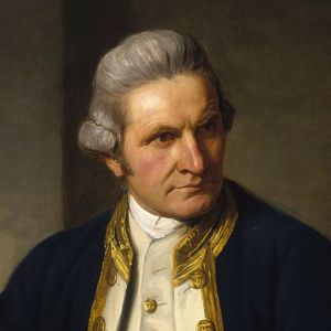
Captain James Cook (1728-1779) was a British explorer, navigator, and cartographer known for his detailed maps and voyages across the Pacific Ocean. He is most famous for his three expeditions, during which he charted large parts of New Zealand, Australia, and the Hawaiian Islands. His first voyage aboard the "Endeavour" (1768-1771) was commissioned by the Royal Society to observe the transit of Venus and explore the South Pacific. Cook's expeditions significantly expanded European knowledge of the Pacific, though his encounters with indigenous peoples sometimes led to conflict, and he was ultimately killed in Hawaii during his third voyage.
Author's Books:
Sort by:
by:
James Cook
All Bearings and Courses hereafter-mentioned, are the true Bearings and Courses, and not by Compass. Cape Chapeaurouge. Cape Chapeaurouge, or the Mountain of the Red Hat, is situated on the West side of Placentia Bay, in the Latitude of 46° 53' North, and lies nearly West 17 or 18 Leagues from Cape St. Maries; it is the highest and most remarkable Land on that Part of the Coast, appearing above...
more...
by:
James Cook
CHAPTER I. Passage from Ulietea to the Friendly Isles, with a Description of several Islands that were discovered, and the Incidents which happened in that Track. 1774 June On the 6th, being the day after leaving Ulietea, at eleven o'clock a.m., we saw land bearing N.W., which, upon a nearer approach, we found to be a low reef island about four leagues in compass, and of a circular form. It is...
more...
by:
James Cook
GENERAL INTRODUCTION. Whether the unexplored part of the Southern Hemisphere be only an immense mass of water, or contain another continent, as speculative geography seemed to suggest, was a question which had long engaged the attention, not only of learned men, but of most of the maritime powers of Europe. To put an end to all diversity of opinion about a matter so curious and important, was his...
more...